The water was utterly turquoise across a distance
and utterly colorless in the cup of my hands.
-Ellen Meloy, The Anthropology of Turquoise
PRUDENCE ISLAND: MICRO INVESTIGATIONS OF DYNAMIC EDGES
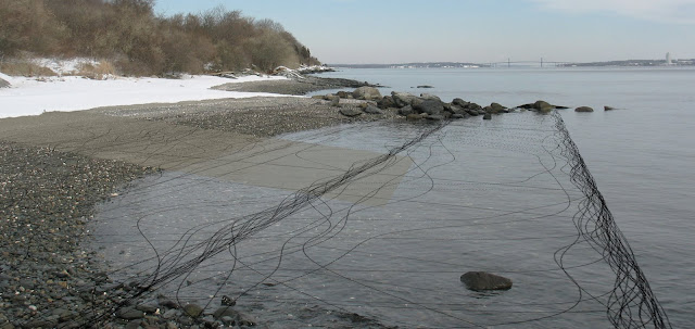
During my initial site visit to Prudence Island I sought to identify natural conditions of dynamic edges similar to what I had artificially created in the dark room for my conceptual studies. This series of micro investigations identifies the condition of water being opaque except at the edge, especially in a solid state. In this regard the dynamic edge is the line or limit between transparency and opacity. This series also reinforces imagery and the evocative nature of water as a concept in my thesis.


The following images describe the visual narrative of existing cultural interventions along the shoreline on Prudence Island.


FLUID TERRAIN
The terrain of Narragansett Bay connects the landform of Prudence Island, or the terrain that we perceive, to its context through a continuous topography. In this model the sectional cuts were created by following the actual topography of Narragansett Bay and Prudence Island for the top of the section cut and an abstraction of geologic information for the bottom of the section cut. The depth of the section cut was determined according to sediment type, where sediment typologies most easily manipulated were modeled as thin conditions and sediment typologies that are more static were modeled as thick conditions. Each section cut begins and ends at the zero contour of the surrounding shoreline of the Bay to the east and west of Prudence Island, and extrudes up through delineation of sea level to model the positive topography of Prudence Island. The delineation of sea level is modeled in clear Plexiglas cut to the frame determined in the drawings on the following pages.


SETTING A FRAME
The watershed of Narragansett Bay defines the greater context of my site. In order to set a frame for my work within the expanse of the watershed I created a composite drawing of both conventional and redefined frames of reference. Horizontal and vertical lines of major latitudes and longitudes create the initial box frame; next a dotted line follows the shoreline of the bay; an additional line is drawn along the -30’ contour to give depth within the shoreline; then the shoreline is bisected at any bridge (a cultural frame of reference, as articulated by sight lines and residents on Prudence Island); the final framing line is drawn by connecting the shoreline with these bridges. One will notice that the zero contour at Prudence Island is only a subset of this frame, as delineated by its line weight, which is lighter than the overall framing line. As a boundary, the frame of my site is particular to both place and perception.


Using the same concept of framing I modeled the topographic conditions of Prudence Island within its context using the bathymetry of Narragansett Bay. The model illustrates what is fixed (topography) versus what is not (water levels) by refusing to conventionally delineate the zero contour with another material. At the scale of Narragansett Bay, the site is framed by relationships between the fluid zero contour, or sea-level, and the perceptions of what cultural elements interact with that horizon, such as iconic bridges and ferry routes. When residents of Prudence Island describe how they orient themselves on the island, it is most often in relation to these cultural elements on the horizon line, or the topographic horizon itself.


CONTEXT DIAGRAMS
In order to continue framing the site in a way that is particular to place and perception a series of cultural relationships warranted investigation. The impetus to create these diagrams came from conversations with local residents in which they described both the tension and attraction between the Island and it’s surrounding context. As previously described, the horizon line and the constructed elements that mark it are how the residents orient themselves on the island. The first image illustrates the viewshed, or the area of land, water, and other environmental elements as perceived from a fixed vantage point, from which these key features can be perceived. The second image maps the navigation routes in Narragansett Bay to, from, and around Prudence Island. While the significance of the contemporary routes is self-explanatory, the historic routes acknowledge landings that were established on Prudence and areas where the Bay was dredged in order to allow for larger boats to navigate the water. The current ferry route which connects Prudence to Bristol draws the strongest cultural connection between the Island and its context, as illustrated in the third image. This image also shows the compromised relationship between Prudence and Portsmouth. As explained by the fourth image, although Prudence Island is politically affiliated with (as a part of) the town of Portsmouth, the financial discrepancies of tax distribution within the municipality have caused a great rift between the Island and mainland. This collection of diagrams frame the site as the residents of Prudence Island understand the activities of exchange that articulate the space the site in a cultural sense.

Viewsheds are drawn from the Homestead Ferry Dock, Sandy Point Lighthouse, T-Wharf, and Old Stone Wharf to the Jamestown Bridge, Newport Bridge, Mt. Hope Bridge, and the Portsmouth wind turbines.

Prudence Island and other contemporary ferry routes are drawn in solid lines; historic steamboat routes and historic naval routes are drawn in dashed lines.

Prudence Island has a positive connection to Bristol (due to ferry connections and jobs); a decent connection is established with Barrington (mainly recreational); a negative connection to Portsmouth (see next diagram); and no real connections to the western towns of Narragansett Bay.

As a part of the Town of Portsmouth, Prudence Island receives a mere .5 million dollars of 2.9 million dollars annual taxes collected by Portsmouth, while the mainland portion of the Town receives the other 2.4 million. The distribution of wealth on Prudence Island is densest at Prudence Park (west side), and lightest/poorest at Homestead (east side), with Sandy Point and Summer Colony in between.
SITE DIAGRAMS
As illustrated above, the winter population on Prudence Island (approximately 125 residents) is concentrated in the neighborhood of Homestead while the summer population (approximately 2000 residents) is distributed across the island, with the greatest influx in population at Sandy Point and Prudence Park. The diagram at the right illustrates this population imbalance in comparison to the availability of resources on Prudence Island, which spikes in the early spring and is quickly diminished by the surge in population during the course of the summer.


Wealthier neighborhoods are shown to have closer proximity to higher elevations, even if they are currently near the shoreline. As the tide pushes inland this will become extremely significant.

Circles delineate wells, shaded regions delineate wildlife management areas, and undulating lines delineate salt marshes. The circulation of water on Prudence is critical to the health of these sites.

Farms, institutions, municipal facilities, religious centers, historic sites, landings, and icons follow the spine of the island and organize the significant social and cultural activities for residents.
MAPPING SYSTEMS
The former United States Naval Base on Southern Prudence Island, as a site with designated park land and which facilitates the Narragansett Bay National Estuarine Research Reserve, was selected as the specific context for this thesis proposal. NBNERR has one main facility at the north of the site that houses both research facilities and an educational exhibit, as well as a small educational facility at the T-Whaft. Their presence on the rest of the site is limited to habitat preservation practices in terms of removal of invasive species and monitored burning to propagate the pine barren. The mapping of soil hydrology, wetlands, and vegetation was necessary in order to identify the critical habitat areas of pine barren forests and wetlands, as well as the overall presence of water on site. On the majority of the site the water table is within 1.5 feet of the surface (wet and moist soil hydrology) or between 1.5 and 3.5 feet (moderately moist soil hydrology). In addition, freshwater wetlands occupy a third of the site. The pine barren habitat is of key importance for conservation measures, as it supports a number of rare species of plants and animals exclusive to pine barrens and is an extremely rare habitat for Rhode Island in itself. The pine barren indicates acidic, sandy, dry soil, in contrast to the moist conditions on the rest of the site.
SOIL HYDROLOGY


VEGETATION

MAPPING THE LAND
To shift the lens of framing from planning to an analysis of terrain it was critical to follow and map the circulation routes across the site as they relate to topography. During the winter many of the roads on site are inaccessible due to snow cover. The majority of the paved roads are remnants of the Navy infrastructure, used to access the bunkers, while the roads outside of the bunkers areas are unpaved and used primarily for habitat maintenance by NBNERR. My first site visit after the spring thaw allowed me to access the entirety of the former Naval Base and catalogue the series of abandoned bunkers and active wetlands that occupy the site. The circulation routes are shown on the Rhode Island Department of Environmental Management map to the near right, and the bunker locations and labels are noted on my diagram on the far right. The organization of the network of bunkers follows the contours of the topography of South Prudence.


BUNKER TYPOLOGIES
As United States Navy artillery installation structures camouflaged by landform, the Prudence Island bunkers were strategically sited within the landscape to protect and store weapons, ammunition, and other items. The act of camouflage is achieved by literally blurring edge conditions. Each bunker is treated as a specific incision on the terrain of the site. Through the process of cataloguing the derelict bunkers on the former Navy Base, five typologies arose, in two main structural categories: the western bunkers were elongated mounds with the an entrance sliced into them, while the eastern bunkers were half-mounds with the bunker entrance located on the vertical plane of exposed side of the half-mound. The later create a wall that can be construed as line of defense, especially in when in close proximity to one another, such as the case in the fifth typology.
Bunker Typology 01:
1BT 11, 1BT 12, 1BT 13, 1BT 16
4AT 36, 4AT 37, 4AT 38, 4AT 39
On Albro Farm Road, Switchgrass Lane,
and Brown Road

Bunker Typology 02:
1WT 14, 1WT 15
On Switchgrass Lane
(Double the width and depth of bunker typology 01)

Bunker Typology 03:
1HT 17, 1HT 18
On an unmarked road

Bunker Typology 04:
3ZC 19, 3ZC 20, 3ZC 21
3XC 22, 3XC 23, 3XC 24
2YC 28, 2YC 30, 2YC 31, 2YC 32, 2YC 33,
2YC 34, 2YC 35
On Mink Avenue, Milkweed Road, Deer Alley,
Twin Tupelo Road, and Birch Bunker Road

Bunker Typology 05:
3PC 25, 3PC26, 3LC 27
On Triple Bunker Road
(Triple configurations of bunker typology 04)

By investigating the site across multiple scales of systems and individual incisions upon terrain, the significance of the individual bunker is set in a larger context in the idea of fortifying the coastal edge. As an advisory member of the Precidio Council, a group that in the 1990s oversaw the conversion a military base in San Francisco to a national park, Maya Lin saw the potential in that site for a landscape to serve as an international magnet towards solving environmental issues.
I think I posed the idea as being a great opportunity to take the idea of defense from being something dealing with the military might, from dealing with machines, army, guns into being the idea of defense defending the world we live in, protecting the environment. That defense in the 21st century should become something else. That as the world gets closer and hopefully we are beginning to get along with each other a little bit better, that we should also focus our concerns on protection, on the defense so to speak of the planet.
-Maya Lin, A Strong Clear Vision
-Maya Lin, A Strong Clear Vision
