VERTICAL FRAMES
The program for my thesis was first discussed as a park, or a park freed from the conventional notion of a park. Building from my conceptual studies, vivid imagery and illumination were employed to give dimensionality to edges and planes and evoke the idea of community on the water. As John Stilgoe writes in the Shallow Water Dictionary, “sea-marks” can be defined in two ways: either as a line on a coast marking the tidal limit, or as an elevated object discernible at for from sea serving as a guide, a beacon, or a landmark.
The T-Wharf was used as a point of entry to the site and as a location for a vertical extrusion over water. As an addition to the context of the iconographic skyline as seen from Prudence Island (of bridges and wind turbines) the proposal of a screen at the end of the T-Wharf is meant to reverse what is perceived on Prudence by placing an icon at the center of Narragansett Bay that would lie in the viewshed from the other icons. This screen could take on a variety of programs, but primarily is proposed as a paddle-in movie theater, which lit up at night would give a new form to the notion of a lighthouse or beacon. This lit up night screen would mimic the condition of water becoming a reflective surface as night. In this regard the water on the site would take on a cultural context by night in its opacity. Below the wharf, scrims would be hung to illuminate the moment of transformation from vertical to horizontal, or section to plan, by blurring that moment with the reflection of the scrims on the water due to their close proximity.
HORIZONTAL FRAMES
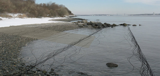
In tandem with the previous vertical screen proposal which uses the opacity of water as a cultural context by night, this horizontal screen proposal uses the transparency of water by day to express an ecological context. The buoyed screens could facilitate ecological monitoring of sediments along the shoreline or create micro-habitats as a floating aquarium. The series of horizontal frames could be explored as an archipelago either by paddling through them or by viewing them from the wharf. By dislocating these screens from the land’s edge and yet allowing them to shift with tidal movement, the buoyed form creates a “floating-mark” that assists the larger “beacon” in marking the reaches of the tide. (Stilgoe, 14.) This iteration is able to delineate the continuously fluctuating boundary the water’s surface while establishing a spatial dimension within it.
WALLS AS FRAMES
As a more three-dimensional landscape element, walls give density and strength to the idea of framing, and ground the idea of framing conditions related to water on land. A system of walls can hold, filter, and release circulation of both cultural and natural processes. As a constructed edge, walls have the potential to link the existing infrastructure on the site to its landscape, and to link cultural and natural programs.
This design iteration uses walls to support and frame both agricultural and hydrological processes. The walls follow the watershed of the site to help direct the flow of water. Walls also appear in open field conditions to frame agricultural plots. As the series of walls approach the shoreline, those walls marking water drift to lower elevations, while the walls delineating agriculture are absorbed into the opportunistic planting beds of the slits between beams on the T-Wharf.
By considering the entire island as a series of terraces delineated by its 10’ contour intervals, a system of holding, filtering and releasing resources could be established on a large scale. On the drier western side of the island agricultural plots could be designed with such a system in mind, while the eastern side could mimic the same system with water resources throughout the extensive freshwater wetland present there.

FRAMING SYSTEMS
As a continuation of the previous concept, the flow of water, people, and resources are held, filtered, or released on site through a series of walls in this development. Walls are understood as both an architectural and topographical form, sometimes merging in the typology of the derelict bunkers. Through this understanding, the landscape becomes an active field addressing both bound and transitory conditions.
The western bunker site would be designed to facilitate agricultural systems as a network of small garden plots (as green roofs on the bunkers) connected by a large scale agricultural field at the center of the now empty site. Systems of passage or circulation could lie within the agricultural patterns.
The eastern bunker site would be designed to facilitate the holding, filtering, and releasing of water in conjunction with the freshwater wetland network that runs around the bunkers. Bunkers capture and store rainwater; open field conditions slowly filter water into the aquifer; and a series of walls direct the flow of water and circulation. By delineating systems through the use of walls in the same context as circulation patterns, the resources on the site would be illuminated to those inhabiting it.
This iterative series of designs, although not literally present in the final proposal of the thesis, were critical to the development of materializing terms on site.


